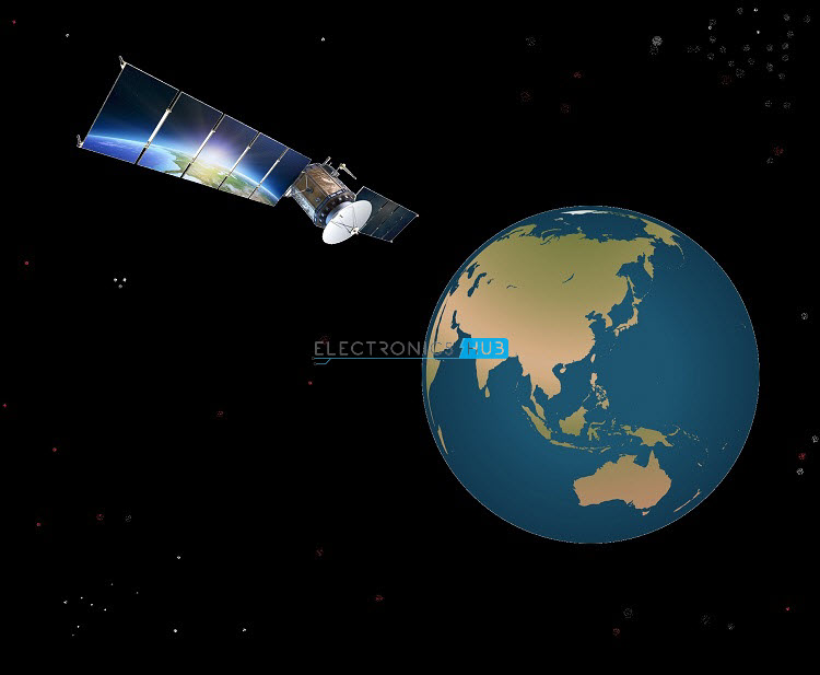
Global Positioning System or GPS is a Global Navigation Satellite System (GNSS) that provides positioning, navigation, and timing system (PNT). It was developed by the United States’ Department of Defense (U.S. DoD) in the early 1970s.
There are other Satellite based Navigation systems like Russia’s GLONASS, Europe’s Galileo and China’s BeiDou, but United States’ Global Positioning System (GPS) and Russian Global Navigation Satellite System (GLONASS) are the only fully functional Satellite based Navigation system with 32 satellite constellation and 27 satellite constellation respectively.
 Global Positioning System
Before the development of GPS Technology, the main aid for navigation (in sea, land or water) are maps and compass. With the introduction of GPS, the navigation and location positioning became very easy with a position accuracy of two meters or less.
History of GPS
Before the development of GPS, ground based navigation systems like LORAN (Long Range Navigation) by the U.S. and Decca Navigator System by the U.K. are the main technologies for navigation. Both these techniques are based on Radio Waves and the ranges were limited to few hundreds of kilometers.
In the early 1960s, three of United States Government Organizations namely National Aeronautics and Space Administration (NASA), Department of Defense (DoD) and Department of Transportation (DoT) along with several other organizations started developing a satellite based navigation system with the aim of providing high accuracy, weather independent operation and global coverage.
This program evolved in to Navigation Satellite Timing and Ranging Global Positioning System (NAVSTAR Global Positioning System). This system was first developed as a military system to fulfil the needs of United States Military.
The U.S. Military used NAVSTAR for navigation as well as weapon system targeting and missile guiding systems. The possibility of enemies using this navigation system against the United States is the main reason why civilians were not given access to it.
The first NAVSTAR satellite was launched in 1978 and by 1994 a full constellation of 24 satellites were placed in the orbit and thus making it completely operational.
 In 1996, the U.S. Government recognised the importance of GPS to civilians and declared a dual use system, allowing access to both military and civilians.
GPS Structure Overview
The fundamental technique of the satellite based navigation system Global Positioning System (GPS) is to measure the distances between the receiver and a few satellites that are simultaneously observed.
The positions of these satellites are already known and hence by measuring the distance between four of these satellites and the receiver, the three coordinates of the GPS receiver’s position i.e. latitude, longitude and altitude can be established. Since the change in position of the receiver can be determined very accurately, the velocity of the receiver can also be determined.
GPS Segments
The structure of this complex Global Positioning System is divided into three major segments: The Space Segment, The Control Segment and The User Segment. In this, the control segment and the space segment are developed, operated and maintained by the United States Air Force. The following image shows the three segments of the GPS system.
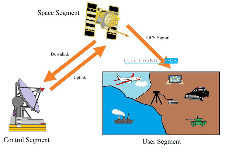
Space Segment
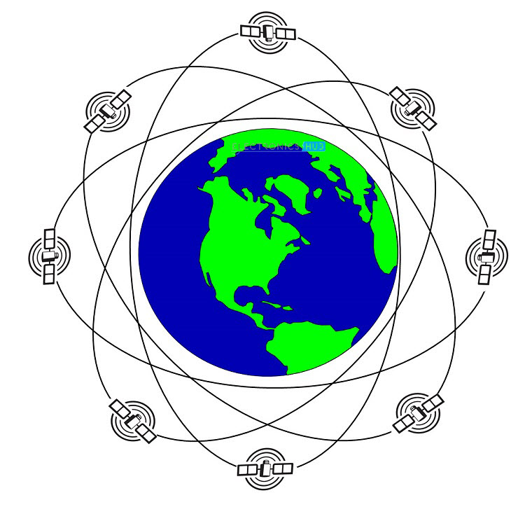
The Space Segment (SS) of the GPS consists of a constellation of 24 satellites that are orbiting around Earth in approximately circular orbits. The satellites are placed in six orbital planes with each orbital plane consisting of four satellites. The inclination of the orbital planes and the positioning of the satellites is arranged in a particular ways such that a minimum of six satellites are always in line of sight from any location on Earth.
Coming to the arrangement of the constellation in the space, the GPS Satellites are placed in the Medium Earth Orbit (MEO) at an altitude of approximately 20,000 KM. To increase the redundancy and improve accuracy, the total number of GPS Satellites in the constellation have been increased to 32, out of which 31 satellites are operational.
Control Segment
The Control Segment (CS) of the GPS consists of a network of worldwide monitoring and control and tracking stations. The primary task of the control segment is to track the position of the GPS Satellites and maintain them in proper orbits with the help maneuvering commands.
Additionally, the control system also determine and maintain the on board system integrity, atmospheric conditions, data from atomic clocks and other parameters.
The GPS Control Segment is again divided into four subsystems: a New Master Control Station (NMCS), an Alternate Master Control Station (AMCS), four Ground Antennas (GAs) and a worldwide network of Monitor Stations (MSs).
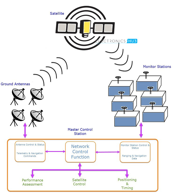 The central control node for the GPS Satellite Constellation is the Master Control Station (MSC). It is located at Schriever Air Force Base, Colorado and operates 24×7.
The main responsibilities of the Master Control Station are: Satellite maintenance, Payload monitoring, synchronizing atomic clocks, Satellite maneuvering, managing GPS Signal performance, uploading Navigation Message data, detecting GPS Signaling failures and responding to those failures.
There are several Monitor Stations (MS) but six of them are important. They are located at Hawaii, Colorado Springs, Ascension Island, Diego Garcia, Kwajalein and Cape Canaveral. These Monitor Stations continuously track the position of the satellites and the data is sent to Master Control Station for further analysis.
In order to transmit data to satellites, there are four Ground Antennas (GA) located as Ascension Island, Cape Canaveral, Diego Garcia and Kwajalein. These antennas are used to uplink data to satellites and the data can be anything like Clock correction, Telemetry Commands and Navigation Messages.
User Segment
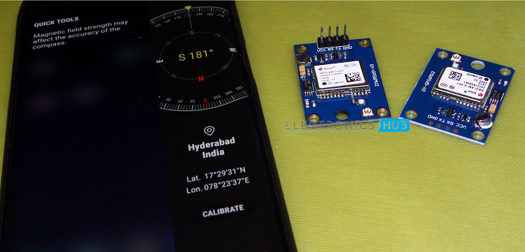
The User Segment of the GPS system consists of end user of the technology like civilians and military for navigation, precise or standard positioning and timing. Generally, in order to access the GPS services, the user has to be equipped with GPS Receivers like Stand – alone GPS Modules, Mobile Phones that are GPS enabled and dedicated GPS Consoles.
 With these GPS Receivers, civil users can know standard position, accurate time and speed while the military uses them for precise positioning, missile guidance, navigation, etc.
Working Principle of GPS
With the help of GPS Receivers, we can calculate the position of an object anywhere on Earth either in two – dimensional or three – dimensional space. For this, GPS receivers use a Mathematical method called Trilateration, a method using which the position of an object can be determined by measuring the distance between the object and few other object with already known positions.
So, in case of GPS Receivers, in order to find out the location of the receiver, the receiver module has to know the following two things:
• Location of the Satellites in the space and
• Distance between the Satellites and the GPS Receiver
Determining the Location of the Satellites
In order to determine the location of the satellites, the GPS Receivers makes use of two types of data transmitted by the GPS Satellites: the Almanac Data and the Ephemeris Data.
The GPS Satellites continuously transmit its approximate position. This data is called the Almanac data, which is periodically updated as the satellite moves in the orbit. This data is received by the GPS Receiver and stored in its memory. With the help of Almanac data, the GPS Receiver can be able to determine the orbits of the satellites and also where the satellites are supposed to be.
The conditions in the space cannot be predicted and there is a huge chance that the satellites might deviate from their actual path. The Master Control Station (MCS) along with the dedicated Monitor Stations (MS) track the path of the satellites along with other information like altitude, speed, orbit and location.
If there is any error in any of the parameters, the corrected data is sent to the satellites so that they stay in exact position. This orbital data sent by the MCS to satellite is called Ephemeris Data. The satellite, upon receiving this data, corrects its position and also sends this data to the GPS Receiver.
With the help of both the data i.e. Almanac and Ephemeris, the GPS Receiver can be able to know the exact position of the satellites, all the time.
Determining Distance between the Satellites and GPS Receiver
In order to measure the distance between the GPS Receiver and the Satellites, time place a major role. The formula for calculating the distance of the satellite from the GPS Receiver is given below:
Distance = Velocity of Light x Transit Time of the Satellite Signal
Here, the Transit Time is the Time taken by the Satellite Signal (Signal in the form of Radio Waves, sent by the Satellite to GPS Receiver) to reach the Receiver.
The velocity of the light is a constant value and is equal to C = 3 x 10⁸ m/s. In order to calculate the time, first we need to understand the signal sent by the Satellite.
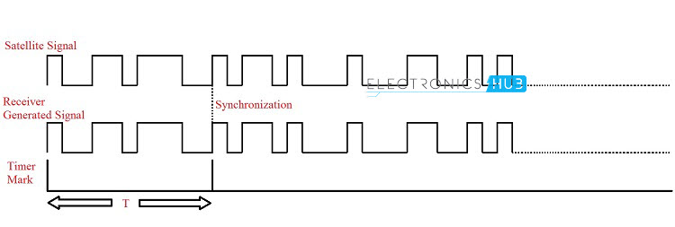
The Transcoded Signal transmitted by the Satellite is called Pseudo Random Noise (PRN). As the satellite generates this code and starts transmitting, the GPS Receiver also starts to generate the same code and tries to synchronize them.
The GPS Receiver then calculates the amount of time delay the Receiver generated code has to undergo before getting synchronised with the satellite transmitted code.
 Once the location of the satellites and their distance from the GPS Receiver are known, then finding out the position of the GPS Receiver in either 2D Space or 3D Space can be done using the following method.
Position of Receiver in 2-D Plane
In order to find the position of the object or GPS Receiver in 2 – Dimensional space i.e. an X-Y Plane, all we need to find is the distance between the GPS receiver and two of the satellites. Let D1 and D2 be the distance of the Receiver from Satellite 1 and Satellite 2 respectively.
Now, with the satellites at the center and a radius of D1 and D2, draw two circles around them on an X-Y Plane. The pictorial representation of this case is shown in the following image.
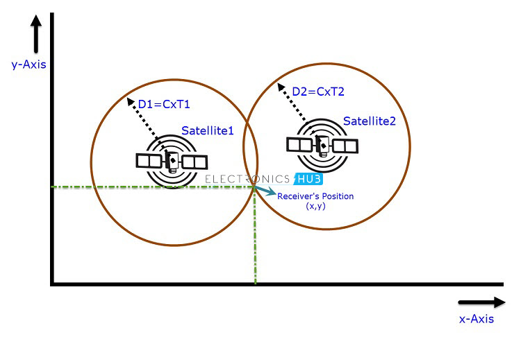 From the above image, it is clear that the GPS Receiver can be located at either of the two points where the two circles intersect. If the area above the satellites is excluded, we can pin point the position of the GPS Receiver at the point of intersection of the circles beneath the satellites.
The distance information from two satellites is sufficient in order to determine the position of the GPS Receiver in a 2-D or X-Y Plane. But the real world is a 3 – Dimensional Space and we need to determine the 3 – Dimensional position of the GPS Receiver i.e. its Latitude, Longitude and Altitude. We will see a step – by – step procedure to determine the 3 Dimensional location of the GPS Receiver.
Position of the Receiver in 3D Space
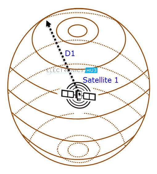
Let us assume that the locations of the satellites with respect to the GPS Receiver are already known. If Satellite 1 is at a distance of D1 from the Receiver, then it is clear that the position of the receiver can be anywhere of the surface of the sphere that is formed with satellite 1 as center and D1 as its radius.
 If the distance of a second satellite (Satellite 2) from the receiver is D2, then the position of the receiver can be limited to the circle formed by the intersection of two spheres with radii D1 and D2 with Satellites 1 and 2 at the centres respectively.
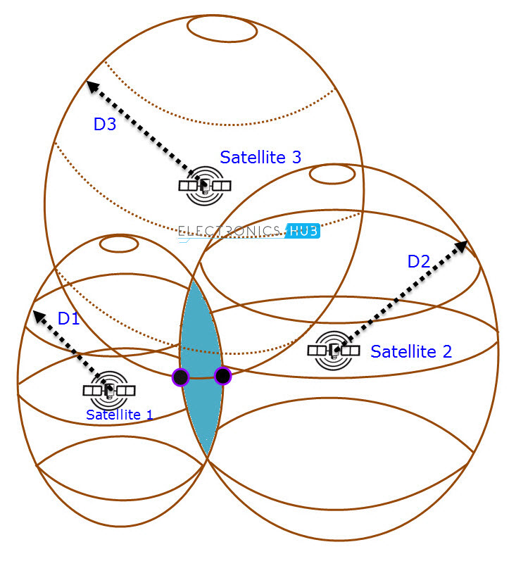
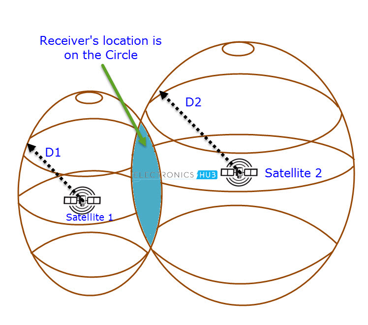 From this image, the position of the GPS Receiver can be narrowed down to a point on the circle of intersection. If we add a third satellite (Satellite 3) with a distance D3 from the GPS Receiver to the existing two satellites, then the location of the receiver is confined to the intersection of the three spheres i.e. either of the two points.
 In real time situations, having the ambiguity of GPS Receiver located at one out of the two positions is not viable. This can be resolved by introducing a fourth satellite (Satellite 4) with a distance D4 from the receiver.
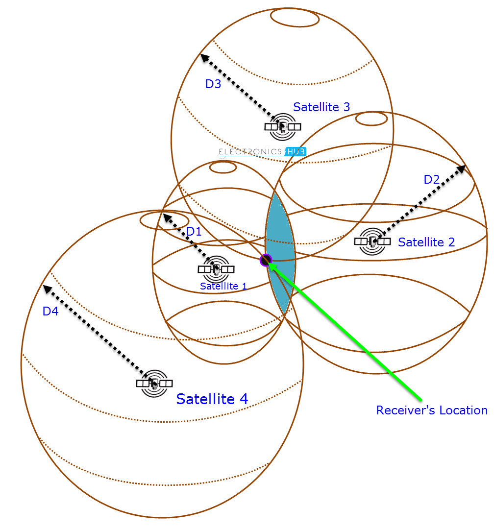 The fourth satellite will be able to pin point the location of the GPS Receiver from the possible two locations which were determined earlier with only three satellites. Hence, in real time, a minimum of 4 satellites are required to determine the exact location of the object.
Practically, the GPS System works such that at least 6 satellites are always visible to an object (GPS Receiver) located anywhere on Earth.
Types of GPS Receivers
The GPS is utilized by both civilians and military. Hence, the types of GPS receiver can be classified in to Civilian GPS Receivers and Military GPS Receivers. But the standard way of classification is based on the type of code that the receiver can be able to detect.
Basically, there are two types of codes that a GPS Satellite transmits: Coarse Acquisition Code (C/A Code) and P – Code. The consumer GPS Receiver units can detect only C/A Code. This code is not accurate and hence the civilian positioning system is called Standard Positioning Service (SPS).
The P – Code, on the other hand is used by the Military and is a highly accurate code. The positioning system used by the military is called Precise Positioning Service (PPS). The GPS Receivers can be classified based on the ability to decode these signals.
Another way to classify commercially available GPS receivers is based on the capability of receiving signals. Using this method, GPS Receivers can be divided into:
- Single – Frequency Code Receivers
- Single – Frequency Carrier – Smoothed Code Receivers
- Single – Frequency Code & Carrier Receivers
- Dual – Frequency Receivers
Applications of Global Positioning System (GPS)
GPS has become an essential part of the Global Infrastructure, similar to the Internet. GPS has been the key element in the development of a wide range of application spreading across different aspects of modern life. Increase of large scale manufacturing and miniaturisation of components has reduced the price of GPS Receivers. A small list of applications where GPS plays an important role is mentioned below.
- Modern agriculture has seen a boost in production with the help of GPS. Farmers are using GPS Technology along with modern electronic devices to get precise information about field area, average yield, fuel consumption, distance covered, etc.
- In the field of automobiles, automated guided vehicles are the most often used in the industrial or consumer applications. GPS enables these vehicles in navigation and positioning.
- Civilians use GPS Receivers for navigation purpose. The GPS receiver can be a dedicated module or an embedded module in mobile phones and wrist watches. They are very helpful in trekking, road trips, driving, etc. Additional features include accurate time and speed of the vehicle.
- Emergency services like fire and ambulance benefit from the accurate positioning of the disaster location by GPS and can be able to respond on time.
- Military uses high precision GPS receivers for navigation, target tracking, missile guidance systems, etc.
There are numerous other applications where GPS is being used or a huge scope of use in the future.